For all surveys completed in accordance with the Surveying and Spatial Information Regulation 2017, please refer to this page.
A plan and associated document(s) must comply with the requirements of the Lodgment Rules.
New easements should be identified on the face of the plan using alpha symbols only.
The description and width of the easement should be consistent:
- in the statements panel on the Administration Sheet of the plan
- in the section 88B instrument and
- on the face of the plan.
The plan must contain sufficient information to define the site of:
- any affecting interest (an easement, restriction on the use of land, positive covenant or profit à prendre) that is intended to be created as a consequence of the registration of the plan and
- any easement profit à prendre intended to be partially released as a consequence of the registration of the plan and
- any proposed affecting interest, or proposed variation or proposed partial release of an easement or profit à prendre
- and where necessary, must also contain sufficient information to indicate the relationship of any such affecting interest to the boundaries of any affected parcel or lot.
NOTE: Profits à prendre, restrictions on use of land and positive covenants affect the entirety of the parcel unless listed as "part designated '......'" in the schedule of lots burdened set out in the section 88B instrument. No width is to be stated on the Administration Sheet or section 88B instrument. If required, connections may be shown on the plan (in brackets) to define the site of a part restriction or positive covenant.
For further information, see New Restrictions on the use of land and positive covenants.
A new easement site should be shown on the plan in one of the following ways:
- the site can be created over the entirety of the parcel
- the site can be created as a strip of land of specified width or as land of variable width. In either case the width of the easement must be stated. The essential dimensions of the site must be shown by bearing and distance see section 64 (3) Surveying and Spatial Information Regulation 2024. The dimensions should be sufficient to define the extent of the site of the easement:
- where it intersects a boundary of land held in different ownership or
- where it terminates at a boundary, whether or not the adjoining land is held in different ownership
- the site can be identified by the centreline traverse along, for example, the towers of electricity transmission line. The centreline should be fully dimensioned and connections to the centreline shown at each title boundary. The outside extremities of the easement should be shown (without dimensions). The width of the easement must be shown, see Easements for physical structures.
NOTE: Only easements along a physical line of poles, transmission lines, towers, etc. (or a line of pegs placed to locate the position of a future line of poles) may be defined by a centreline traverse.
- the easement can be created over an existing physical feature (e.g. track in use, storm water detention basin, open bore drain, significant tree, etc.) referred to in the section 88B instrument. No width is required. For further information, see Easements for physical Structures or Easement over track in use pages
- a cross-easement to be created under section 48 Real Property Act 1900 or section 88BB or section 181B Conveyancing Act 1919 will require the site of the party wall to be defined by survey on the common boundary of the lots concerned. The party wall should be appropriately designated on the plan, for example:
'CENTRE 0.23 BRICK PARTY WALL'
Or
'NORTHERN FACE OF 0.23 BRICK PARTY WALL'
Or
'0.23 BRICK PARTY WALL'
NOTE: If the parcel boundary does not pass through the centre of the party wall or along one of its faces, the plan must show sufficient connections at each extremity and bend in the wall or boundary to define the relationship between the wall and boundary. An appropriate designation is required (e.g. '0.23 BRICK PARTY WALL').
For further information, see Cross-easements page.
- an easement can be created along a waterfront, river bank or other natural boundary.
An easement only plan defined by a plan of survey must be marked in accordance with sections 42(4) and 54 Surveying and Spatial Information Regulation 2024, see Placement of permanent marks and Boundary and reference marks.
Easements with multiple widths
The creation of a single easement with multiple widths is acceptable, however discretion is advised should this course of action be undertaken. For example, a section 88B instrument is creating an easement to drain water 2 wide, 3 wide and 5 wide, which is for a single series of pipes, where the pipes become larger the further the water is drained through the pipes (see Easement plan Example 1 below).
In this example a particular parcel of land may have the site of the easement shown as 2 wide within the lot on the plan. Therefore, as a result of the way the easement has been created, the folio of the register will be endorsed with the notification 'Easement to drain water 2 wide, 3 wide and 5 wide affecting the part(s) shown so burdened in the title diagram'. This can create confusion for practitioners and land owners where not all of the designated widths of the easement apply to an individual parcel. However, creating the easement in this way is acceptable.
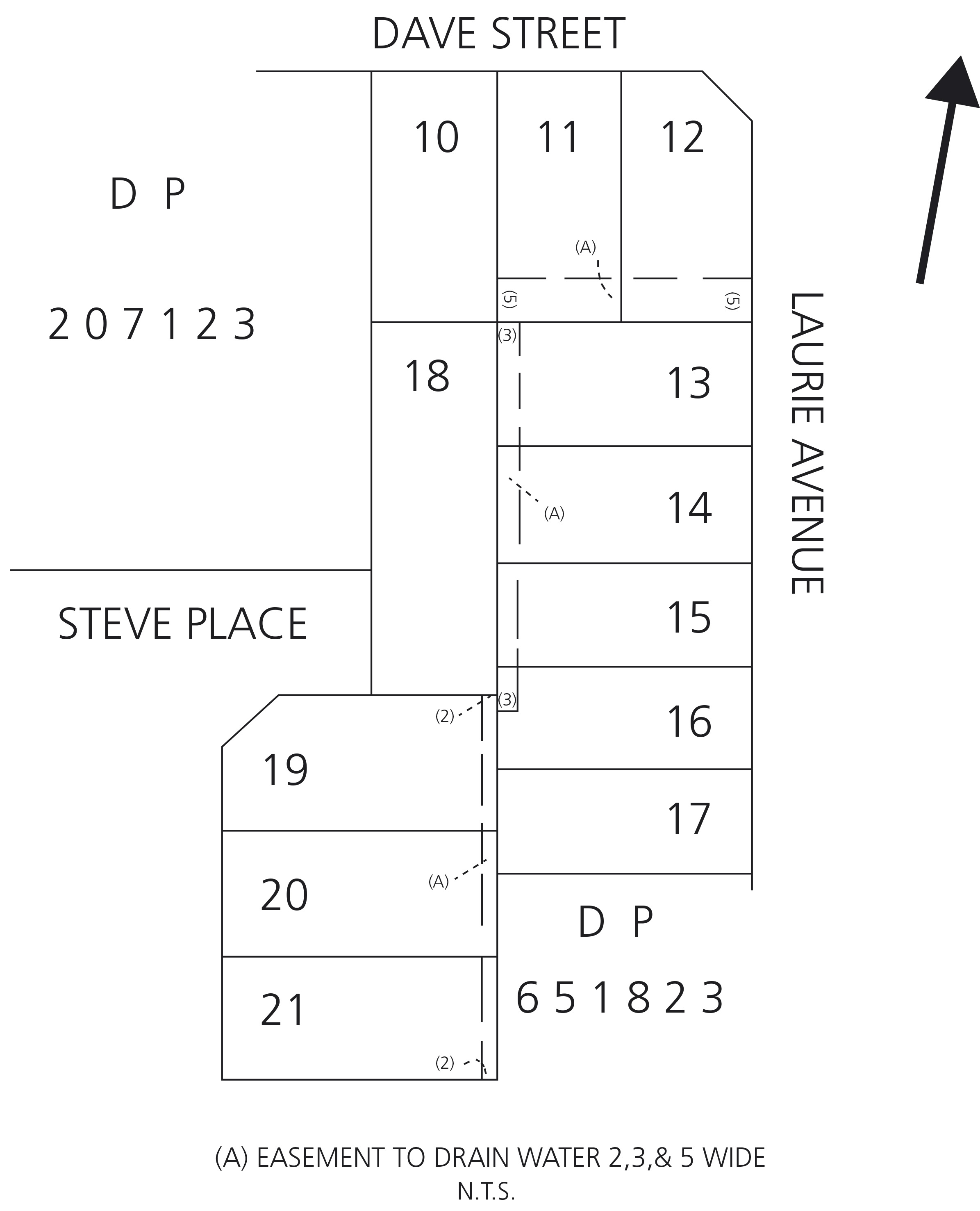
Easement plan - Example 1
What should be avoided is a single easement being created with multiple widths over a number of different sites within the same lot. For example, a plan designates easements sites within a large residual lot. The easement is created as a single easement however it is for three separate easement sites positioned hundreds of metres apart. See Easement plan Example 2 below.
Caution is advised when creating an easement by this method. Issues may be encountered when the residual parcel is subdivided. Numerous parties may need to consent to the release even though these parties cannot physically access the site of the easement. It can be an arduous task to obtain the consents of all the owners of the dominant tenements and other parties having an interest in the burdened land. To avoid the requirement of obtaining numerous consents to release an easement for example in the diagram above, it is suggested to create separate easements for where each easement changes width.
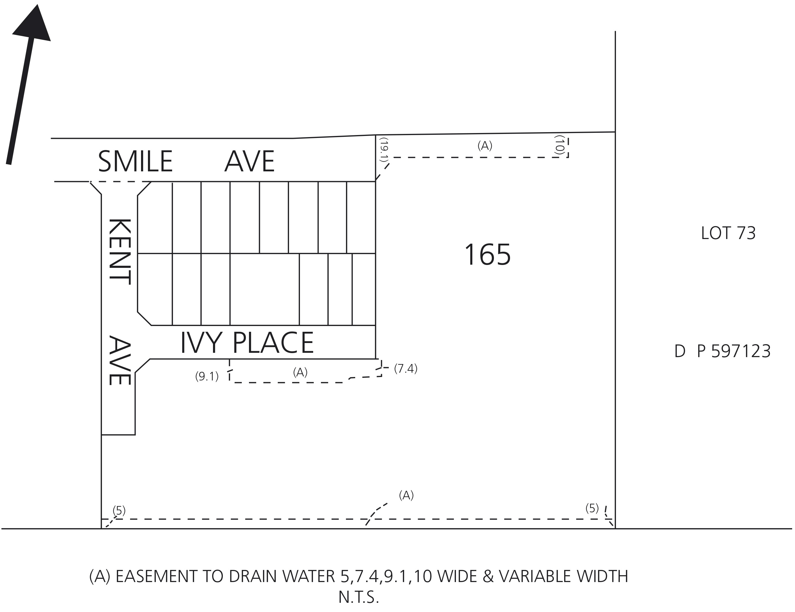
Easement plan - Example 2
NOTE: Notifications in newly created folios of the Register reflect the widths of the easements as specified in the section 88B instrument.
Easements affecting new roads
Where part of the land in a plan is being dedicated as a public road, road widening or pathway and is burdened by an existing easement, the following procedures will apply:
- the easement site should be defined and
- the statement of intention to dedicate the road in the statements panel on the Administration Sheet should be stated as being subject to the easement and the statement of intention should be accepted by the authorised person, general manager of the council or accredited certifier.
The parties benefiting from the easement are not required to sign the plan.
Easements may also be created appurtenant to new roads dedicated in a deposited plan. This is a common stipulation for council's consent to the subdivision. Reference to the relevant street or road should be included in the schedule of lots benefited set out in the section 88B instrument. The section of road that will have a dominant right over the easement should be clearly identifiable on the new plan.
Easements created over compiled residue lots
An easement can be created affecting the compiled residue lot in a new plan of subdivision. However, unless the new easement complies with compiled plan guidelines or is for electricity purposes and defined by the centreline of an existing line of poles, the new site must be surveyed and appropriately marked in accordance withsections 42(4) and 54 Surveying and Spatial Information Regulation 2024. See also Compiled easement plans and Easements for physical structures (existing line of poles) pages.
All NSW legislation can be accessed at www.legislation.nsw.gov.au/
Publication Date: July 2025