For all survey's completed in accordance with the Surveying and Spatial Information Regulation 2017, please refer to this page.
In most cases it is understood that the land shown in a deposited plan is, theoretically, unlimited in both height and depth. However, a plan may be prepared whereby an upper and/or lower height limitation is placed on a lot or affecting interest. These lots are described as stratum lots and their upper and lower limits are defined by stratum boundaries. The stratum boundaries may be horizontal planes defined at a fixed level or inclined planes defined by multiple levels.
Plan requirements
Plans which create or redefine any stratum limitation must, in addition to complying with all of the usual plan requirements, contain sufficient information to adequately define the stratum of each lot or affecting interest and comply with sections 23, 24, 29, 37, 43, 47, 63 and 67 Surveying and Spatial Information Regulation 2024.
Section 29 Surveying and Spatial Information Regulation 2024 requires that the levels in plans must be related to Australian Height Datum (AHD) or other datum approved by the Surveyor General.
All heights shown must be verified by closed height difference between 2 or more bench marks that each have accurate AHD values (see below). The heights should be described on the plan as Reduced Levels,e.g. RL 27.1
Stratum boundaries can be defined by:
-
the upper and lower limit of the lot(s) defined by RL(s) on the face of the plan, a statement(s) defining the RL’s or a combination of both
-
the lower limit of the lot(s) defined by RL’s on the face of the plan or by a statement and the upper limit defined with reference to the lower limit of the level above. This method minimises the risk of overlap or hiatus between the lots e.g.:
BASEMENT LEVEL 2 AND BELOW
LOTS SHOWN ON THIS SHEET ARE UNLIMITED IN DEPTH AND ARE LIMITED IN HEIGHT TO THE LOWER LIMITS OF THE LOTS SHOWN ON BASEMENT LEVEL 1 ON SHEET 3. UNLESS OTHERWISE NOTED, EASEMENTS ARE LIMITED IN STRATUM TO THE STRATUM LIMITS OF THE BURDENED LOTS ON THIS LEVEL.
NOTE: if a concrete floor or other permanent structure is intended to be used as a monument for defining the boundary, then the usual requirements apply in terms of showing the relationship between the monument and the stratum boundary (ie offsets), and/or statements identifying relationship between the monument and the stratum boundary (eg upper surface of concrete floor). See Monuments.
Existing easements are considered to be unlimited in height and depth unless expressly limited in stratum by the creating instrument and/or plan. Subsequently, the site of existing easements that are unlimited in stratum must be shown through all applicable levels.
The site of easement(s) created in a new plan that are defined in stratum (limited in height and/or depth) must only be displayed within the applicable RL(s) of the lots. When the RL(s) provided for an easement exceeds the RL provided for the lot(s) on a level, the easement must be displayed through the subsequent level.
The stratum limit(s) of easement(s) must be clearly discernible between the stratum limits of the lots through either stratum statements shown on the plan, RL’s defined within the lot(s) and easement site or preferably a combination of both.
Considering the complexity of many stratum plans, it may be beneficial that a separate sheet(s) is replicated to display easement information only.
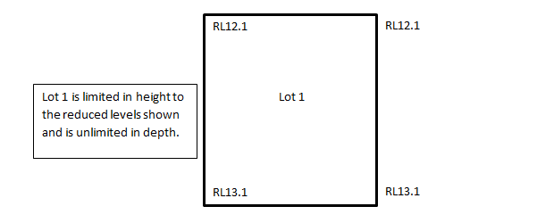
Example 1
- Lot 1 is limited in height to RL 27.1 and unlimited in depth
- The part of lot 2 designated (X) is limited in height to RL 30.75 and is otherwise unlimited in height and depth
If the lot is limited by an inclined plane or planes more detail will be required. RLs should relate to each corner of the stratum lot(s) as required. Where the stratum subdivision is complex it may be necessary to show several plan views at different levels.
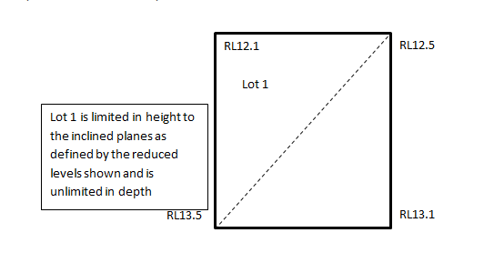
Example 2
It will be likely that each corner of a lot be defined by a reduced level. In some cases, it may be beneficial to use cross sections to clearly define the boundaries.
In this example the upper limit of lot 1 is defined by an incline plan depicted by the reduced levels shown at the corners of the lot
Example 3
- Lot 1 is limited in height by two inclined regular planes defined by the reduced levels shown on the plan and unlimited in depth
In this diagram the upper limit of lot 1 is defined by 2 inclined planes which meet at the broken line.
Example 4
Within a level, variations in RLs of the same lot should not be displayed as separate part lots unless the lot is physically separated. The change in RL within the same lot should be displayed by broken line work with the RLs appropriately defined.

NOTE 1 PART LOT 1 IS LIMITED IN DEPTH TO THE HORIZONTAL PLANE AT RL 17.5 AND LIMITED
IN HEIGHT TO THE LOWER STRATUM OR LOT LIMIT OF THE PART LOT ABOVE
NOTE 5 PART LOT 1 IS LIMITED IN DEPTH TO THE HORIZONTAL PLANE AT RL 19.35 AND LIMITED IN HEIGHT TO THE LOWER STRATUM OR LOT LIMIT OF THE PART LOT ABOVE
NOTE: for further examples, please see Examples of Stratum Boundaries.
Cross-sections
Although not required a surveyor may choose to define the stratum boundaries by providing across section.
A cross section is the representation of the stratum, through a vertical plane, of the lots visible when viewed along a designated line. The designated line is referred to as the section line. The section line must be identified in the plan view. The direction of view is shown in the plan views by arrows at the terminals of the section line see below
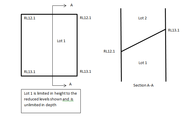
Cross sections assist with visualising the vertical relationship of building levels, lot boundaries, easements and occupations.

Where any substantial structure (including a fence, concrete floor, wall, driveway, ramp etc) is within 1 metre of a boundary related to AHD, the requirements of section 63(1)(k) Surveying and Spatial Information Regulation 2024 apply.
Isolated Lots
Internal isolated lots must be connected to the extremity of the surveyed site e.g.:

Unacceptable stratum definition
It is not acceptable to define a stratum boundary by a curve or curves. All boundaries must be horizontal or inclined regular planes.
Defining stratum limits by abuttals (i.e. reference to an adjoining lot) is not acceptable.
Reference to a natural or structural feature may be shown on the plan provided the stratum boundary of the lot or affecting interest is defined by reference to AHD.
NOTE: Where it is intended to adopt the natural or structural feature as a monument, this will take precedence over measurement (AHD).
Areas of stratum lots
Areas must be provided for stratum lots to the same general requirements of a non-stratum lot as follows:
- areas are to be shown only in the plan view,
- each part lot must have a part area,
- the total area must be provided within or related to the most significant part of each lot,
- there will be no objection to the total area indicating the number of parts, e.g. Total Area (5 parts) 700 m2
- a schedule must be provided of the total lot areas with the sum of each part. The schedule must be shown on sheet 1 of the site/footprint diagram e.g.
.jpg "tabl-1-(1).jpg")
- a table of lot(s) footprint areas may also be displayed on sheet 1 of the site/footprint diagram. A footprint area is determined by compressing the levels to the surface and determining the total area occupied by each lot (disregarding overlaps) e.g.

NOTE:THE TOTAL AREAS SHOWN ABOVE DO NOT INCLUDE PARTS OF THE SAME LOT THAT OVERLAP IN PLAN VIEW
Bench marks
A bench mark by definition means a survey mark of the kind referred to in Schedule 1 Surveying and Spatial Information Regulation 2024. If the plan is for the purpose of limiting a lot or an affecting interest in either height or depth then the surveyor must relate the plan to at least 2 bench marks that each have accurate AHD values in accordance with sections 23, 24, 29, 37, 43, 47 and 63 Surveying and Spatial Information Regulation 2024, and:
- connect to 2 bench marks within 250 metres of the land surveyed
- at least 1 of the bench marks must be within 30 metres of the land surveyed
- at least 1 of the bench marks must be a permanent survey mark
- the approximate position of each bench mark must be shown on the plan using the appropriate symbol (bench mark or permanent survey mark) shown in Schedule 5 Surveying and Spatial Information Regulation 2024
- the details of each bench mark must be recorded in a coordinate schedule and a height schedule on the plan. See section 67 Surveying and Spatial Information Regulation 2024.
- height comparisons between bench marks must be recorded in a height difference schedule on the plan. See section 67 Surveying and Spatial Information Regulation 2024.
All NSW legislation can be accessed at www.legislation.nsw.gov.au/
Publication Date: March 2025